Beyond the Flames: Wildfire Drone Response Supporting Firefighters on the Ground
Wildfire drone response is changing how agencies detect, map, and extinguish fast‑moving fires across complex terrain. Instead of relying only on manned aircraft and ground crews, wildfire drone response puts agile, sensor‑rich platforms in the air within minutes, delivering live thermal and visual intelligence to incident command. By orbiting above fire lines, neighborhoods, and containment perimeters, drones help commanders see where the fire is hottest, where it is cooling, and where new ignitions could threaten people or critical infrastructure. In this way, wildfire drone response turns the sky into a continuous data source rather than an occasional helicopter fly‑over.
As adoption grows, wildfire drone response now spans the full lifecycle of an incident. In the early phase, drones support detection and size‑up—mapping the fire’s footprint, spotting crown runs or spot fires ahead of the main front, and highlighting at‑risk structures or escape routes. During active operations, they guide engines and hand crews, confirm the effectiveness of dozer lines and back burns, and monitor no‑go zones like steep canyons or heavy snag areas where it would be unsafe to send firefighters. In the crucial mop‑up stage, wildfire drone response shines by using thermal cameras to hunt for lingering hotspots that could reignite, drastically reducing the time and labor needed to walk every blackened acre on foot.
Beyond immediate fire behavior, wildfire drone response is also reshaping training, planning, and post‑incident analysis. Recorded flight logs, orthomosaics, and hotspot maps become powerful after‑action review tools, helping teams refine tactics, validate containment strategies, and document conditions for insurance or regulatory purposes. As fleets expand and integrate with AI, mesh networking, and “drone‑as‑first‑responder” concepts, wildfire drone response is poised to become a standard layer of every major incident—working alongside tankers, helicopters, and ground crews to provide faster intelligence, reduce exposure for firefighters, and ultimately protect more lives and property.
Core Platforms and Sensor Payloads (RGB, thermal, laser rangefinder)
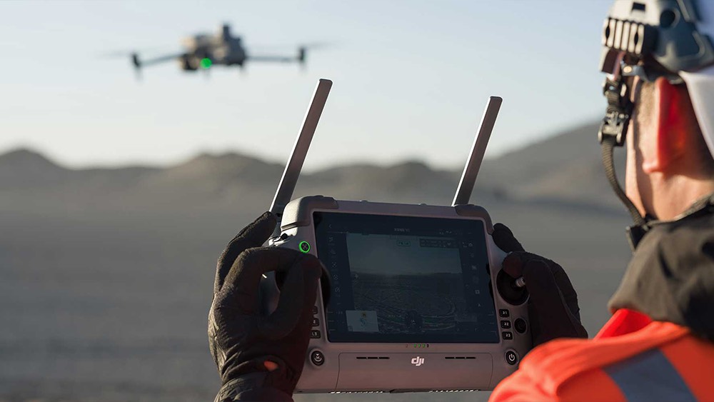
Wildfire drone response relies on a small set of robust airframes paired with powerful sensors that turn raw flight into actionable intelligence. Multirotor platforms with good wind resistance and long endurance carry RGB, thermal, and laser rangefinder payloads so incident commanders see fire behavior, terrain, and remaining hotspots in one integrated picture. With the right mix of hardware, wildfire drone response becomes faster, safer, and far more precise.
RGB mapping cameras
High‑resolution RGB cameras capture detailed visual maps of burn scars, containment lines, and nearby structures. In wildfire drone response these images support perimeter mapping, damage assessment, and documentation for reports or claims. Consistent, repeatable RGB missions give teams a time‑stamped record of fire spread and suppression progress, replacing scattered ground photos with a unified aerial view.Thermal imaging payloads
Thermal sensors are the backbone of wildfire drone response because they reveal heat signatures invisible to the naked eye. Crews use them to spot active flame fronts through smoke, detect spot fires ahead of the line, and hunt lingering hotspots during mop‑up. Accurate temperature mapping ensures resources are directed to true problem areas instead of cold ash that only looks dangerous.Laser rangefinders and LiDAR
Laser rangefinders provide precise distance and elevation readings, anchoring hotspots and features to real‑world coordinates. In advanced wildfire drone response setups, LiDAR or rangefinders help generate 3D terrain models, highlight steep slopes or drainages, and improve flight safety in complex topography. This spatial accuracy is vital when ground crews must navigate at night or in low visibility.Rugged multirotor platforms
Enterprise‑grade multirotor drones carry these payloads while holding position in high winds, heat, and dense smoke. Their ability to hover and climb quickly suits dynamic wildfire drone response, where aircraft may need to zoom into a hotspot, then step back for a wide situational overview. Swappable batteries and IP‑rated airframes keep sorties frequent and reliable.Integrated data links and software
Live video downlinks, encrypted radio links, and mapping software tie all sensors into the incident command system. During wildfire drone response, this ecosystem streams RGB, thermal, and range data to tablets, trucks, and command posts, where it is recorded, annotated, and shared with strike teams. The result is a common operating picture that keeps ground, air, and command units aligned in real time.
Active Firefront Operations: Perimeter Mapping and Hotspot Detection
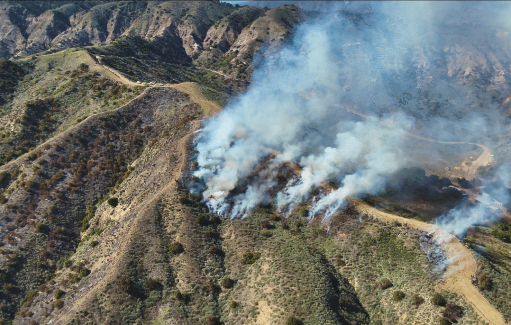
Active firefront operations are where wildfire drone response delivers the most immediate impact. As flames move quickly across ridges, canyons and the wildland–urban interface, drones give incident command a live, overhead view that trucks and hand crews simply cannot match. By flying automated grid or contour missions, wildfire drone response teams can map the perimeter in near real time, helping planners understand where the fire is surging, where lines are holding, and which neighborhoods or assets are at greatest risk.
Perimeter mapping in wildfire drone response typically uses high‑resolution RGB cameras combined with GPS to generate georeferenced orthomosaics and vector fire edges. These perimeter layers feed directly into incident command maps, allowing air attack, dozers and crews to coordinate around a common, current fireline instead of outdated or hand‑drawn sketches.
When updated repeatedly over a shift, this drone‑derived perimeter shows growth direction and speed, guiding decisions about evacuations, resource allocation and back‑burn opportunities with far more confidence.Hotspot detection is the second critical pillar of active firefront work in wildfire drone response. Thermal cameras see through smoke to reveal pockets of intense heat, spot fires launched ahead of the main front, and heat building around structures or unburned islands inside the perimeter.
Operators can tag these hotspots and push coordinates directly to ground divisions, so engines and hand crews move straight to the real problems rather than patrolling blindly. This targeted approach makes suppression more efficient, reduces the chance of surprise flare‑ups, and keeps firefighters out of the most chaotic areas for longer than necessary.
Mop-Up Phase: Drone-Guided Hotspot Hunts and Verification
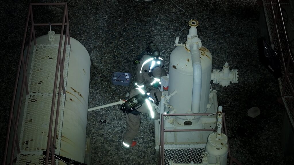
In the mop‑up phase, wildfire drone response shifts from chasing flames to hunting invisible embers that could restart the incident. Crews fly thermal‑equipped drones over the black, systematically scanning containment lines, tree roots, stumps and debris piles for heat signatures that human eyes or handheld cameras might miss. This targeted use of wildfire drone response replaces days of grid‑walking with focused follow‑up on a shortlist of precise coordinates.
Once hotspots are identified, wildfire drone response guides ground teams in like a GPS for heat. Pilots or analysts drop pins on live maps, label priority hotspots, and share them with division supervisors and engines via tablets or printed map products. Firefighters then move directly to those locations, extinguish or trench them out, and call for an immediate re‑scan to confirm the area is truly cold. This feedback loop makes mop‑up more efficient and reduces the risk that a smoldering log or root system will escape attention.
Verification is the final layer where wildfire drone response proves its value. After crews believe a sector is secure, drones run one more thermal pass to validate that no residual heat remains along lines, around structures, or in sensitive drainages and canyons. These flights create a documented, time‑stamped record showing that mop‑up met agreed thresholds, supporting decisions to downgrade resources, lift evacuations, or declare full containment. By combining hotspot detection, guided suppression, and objective verification, wildfire drone response turns mop‑up from a largely manual sweep into a data‑driven, defensible process.

Integrating Drones with Air Attack and Ground Crews
Integrating drones into existing tactics is what turns wildfire drone response from a side project into a true force multiplier. When air attack, ground divisions, and UAS teams share procedures, channels, and map products, drones become another aircraft on the board and another set of eyes for crews, not a distraction. Done right, wildfire drone response improves safety, speeds decision-making, and helps every drop and dozer push count.
Shared command structure
Wildfire drone response works best when drone pilots are embedded in the incident command system, reporting through air ops or a dedicated UAS coordinator. Clear tasking, check‑in/check‑out procedures, and participation in briefings ensure drone objectives align with air attack plans and ground crew priorities, preventing duplicated effort or conflicting assignments.Deconflicted airspace and comms
To integrate safely with tankers and helicopters, wildfire drone response uses altitude blocks, time separation, and standard radio calls. Drones operate only in assigned boxes or windows, and pilots monitor the same air‑to‑ground and command channels as other aircraft. Simple rules—like “no drone operations when manned aircraft are overhead”—keep everyone predictable.Targeting and adjusting drops
Drones can scout ahead of retardant or water drops, sending live video and coordinates to air attack to refine line locations or confirm anchor points. After drops, wildfire drone response provides rapid assessment of coverage gaps, spotting where retardant missed crowns or left dry patches. This feedback loop helps aircraft adjust run angles and makes each sortie more effective.Guiding ground tactics
From the ground perspective, wildfire drone response turns into a mobile lookout. Crews receive hotspot pins, perimeter updates, and structure triage views directly on tablets or through division supervisors. This allows engines and hand crews to choose safer approaches, avoid chimneys and snag patches, and prioritize work where the drone shows the greatest heat or spread potential.Standardized data products
For true integration, wildfire drone response must deliver outputs in formats everyone can use: georeferenced perimeters, KML layers, hotspot shapefiles, and simple annotated screenshots. These feed incident maps, briefings, and after‑action reviews. By standardizing products and delivery times—such as “perimeter update every operational period”—drones become a predictable, trusted part of the fireground toolkit.
Future Trends: Swarms, AI Analytics and Drone-as-First-Responder
Future trends in wildfire drone response are moving toward fleets of cooperating aircraft rather than single, standalone units. In the coming years, wildfire drone response is likely to use swarms of small, inexpensive drones that can launch from multiple points, automatically divide up the fireground, and share data over mesh networks. This will enable near‑continuous mapping of perimeters, spotting of new ignitions, and monitoring of evacuation routes, with far more spatial and temporal coverage than any single drone could provide.
AI analytics will sit on top of these data streams, turning raw pixels into predictions and alerts. Instead of operators manually scanning every frame, machine‑learning models will classify smoke plumes, estimate flame height, predict spread direction, and rank hotspots by re‑ignition risk. Integrated into command software, AI‑driven wildfire drone response can suggest optimal locations for dozer lines, structure protection, or back‑burns, and flag areas where changing winds make current tactics unsafe. Over time, these models will learn from thousands of incidents, steadily improving their guidance.
Finally, drone‑as‑first‑responder concepts will bring wildfire drone response into the very first minutes of an incident. When a 911 call, satellite alert, or camera system detects possible fire, an autonomous drone could launch from a nearby station, reach the scene before any engine, and stream live thermal and RGB video to dispatch and duty officers. That early situational awareness will help decide whether to mobilize a full response, which access routes are safe, and which communities to warn first. Combined with swarms and AI analytics, this next generation of wildfire drone response has the potential to make attacks earlier, more surgical, and significantly safer for both firefighters and the public.