Drone-Based Wildlife Census: Counting Orangutans Above the Borneo Canopy
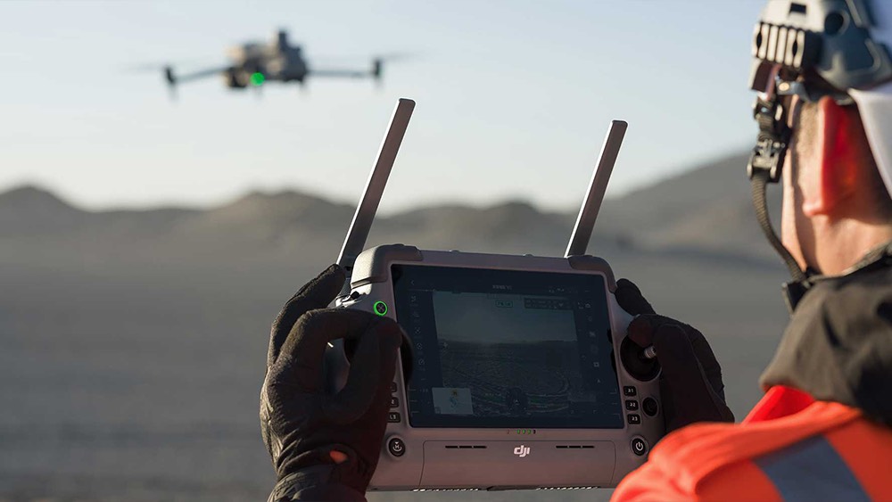
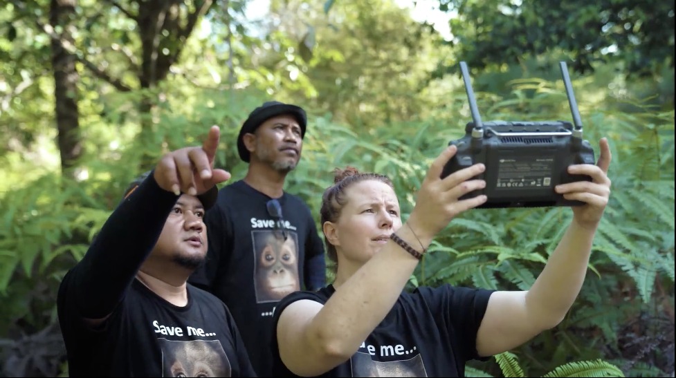
Drone-based wildlife census is rapidly becoming one of the most powerful tools in modern conservation, replacing slow, ground-based surveys with fast, repeatable counts from the sky. Instead of trekking for weeks through dense forests, swamps, or remote savannas, researchers can launch a drone, follow a planned route, and capture high‑resolution RGB and thermal data in a single flight. By standardising these missions and repeating them over seasons, a drone-based wildlife census provides comparable snapshots of animal populations and movements, which is essential for tracking declines, recovery, or the impact of new protections.
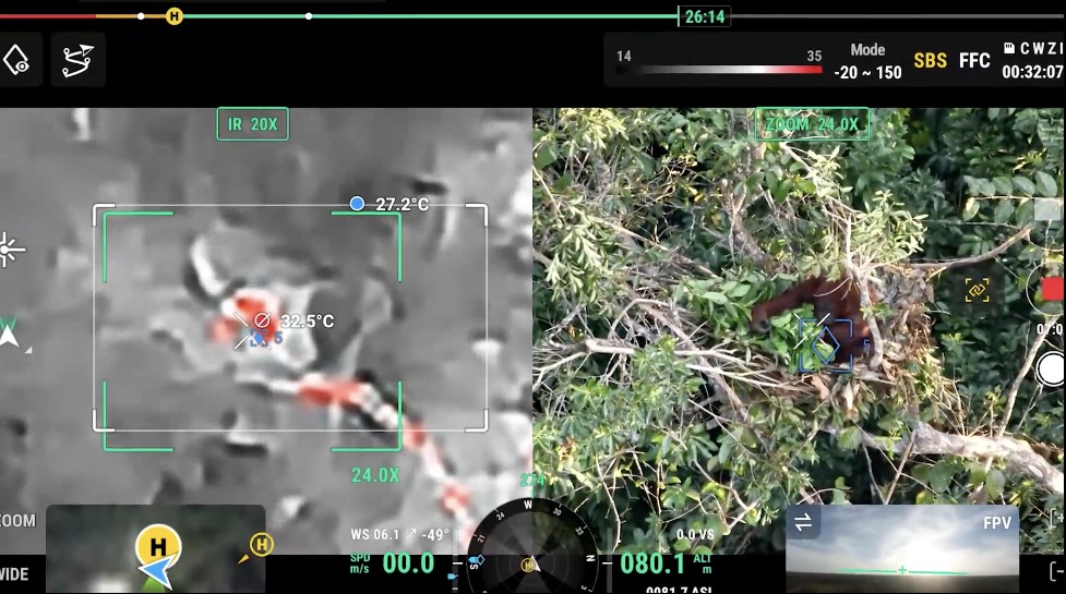
A key advantage of a drone-based wildlife census is that it can detect animals directly, not just signs like nests, tracks or dung. Thermal sensors pick up the heat signatures of mammals hidden in canopy or tall grass, while zoom cameras confirm species, age classes or group sizes without disturbing the animals. Automated image analysis and AI models then scan thousands of frames to detect and count individuals far more consistently than tired human observers. This makes a drone-based wildlife census especially valuable for elusive or nocturnal species such as orangutans, big cats, elephants, marine mammals, and ground‑nesting birds that traditional surveys routinely miss.
Just as important, a drone-based wildlife census reduces risk and impact for both people and ecosystems. Rangers, scientists and volunteers no longer need to spend as much time in dangerous terrain or close to potentially stressed animals, lowering the chances of accidents and disease transmission. At the same time, drones can fly higher and quieter than manned aircraft typically used for aerial surveys, cutting noise and fuel use while still delivering detailed data. When combined with GPS tags, habitat maps and long‑term monitoring programmes, a well‑designed drone-based wildlife census becomes a cornerstone of evidence‑based conservation, helping agencies decide where to focus anti‑poaching patrols, which habitats to restore first, and how to demonstrate that protection efforts are truly working.
Why Conservation Needs Drone-Based Wildlife Census
Conservation needs drone-based wildlife census because it finally gives scientists fast, accurate, and repeatable data on animal populations across huge, hard‑to‑reach landscapes. A drone-based wildlife census can cover remote forests, wetlands, deserts, and coastlines in a fraction of the time required for foot or vehicle surveys, while capturing high‑resolution imagery and thermal data that reveal animals people would simply miss. With climate change and habitat loss accelerating, those timely insights are critical for deciding where to focus limited conservation resources.
Another reason conservation depends on drone-based wildlife census is the improvement in data quality and safety. Traditional counts often rely on indirect signs like nests or tracks and can suffer from inconsistent methods between teams or years, making trends hard to trust. In contrast, a drone-based wildlife census follows pre‑planned flight paths and sensor settings, creating a consistent, auditable record that can be re‑analysed as detection algorithms improve. At the same time, drones keep rangers and researchers out of dangerous terrain and away from potentially stressed or aggressive animals, reducing the risk of accidents and disease transmission.
Finally, a drone-based wildlife census helps link population numbers to real management action. Because drones can be flown more frequently and cheaply than manned aircraft, conservationists can track how animals respond to new protected areas, anti‑poaching patrols, reforestation projects, or human encroachment almost in real time. That feedback loop makes it easier to prove which interventions work, justify funding, and adapt strategies before declines become irreversible. In an era where every year counts for many endangered species, the precision and efficiency of a drone-based wildlife census turns monitoring from an occasional snapshot into a powerful, ongoing decision-support system.
Core Platforms and Sensors (RGB, Thermal, Multispectral)
Core platforms and sensors are what turn a drone-based wildlife census from simple aerial photography into a rigorous scientific method. A well-designed drone-based wildlife census matches the aircraft and payload to the habitat, species, and altitude, balancing resolution, coverage, and battery life. By combining RGB, thermal, and multispectral sensors on stable platforms, a drone-based wildlife census can detect animals, map their habitats, and monitor change over time with far greater precision than ground surveys alone.
RGB mapping cameras
High‑resolution RGB cameras provide sharp visual imagery for identifying species, counting individuals in open habitats, and documenting nesting sites or colony boundaries. In a drone-based wildlife census, RGB data also underpins photogrammetry, producing orthomosaics and 3D terrain models that help link animal locations to landscape features, human disturbance, and access routes for conservation teams.Thermal imaging sensors
Thermal cameras detect heat signatures, allowing a drone-based wildlife census to find mammals and large birds hidden in canopy, tall grass, or at night. By highlighting warm bodies against cooler backgrounds, thermal payloads are particularly valuable for elusive, nocturnal, or camouflaged species, and they reduce reliance on noisy manned aircraft that can disturb animals during sensitive behaviours.Multispectral and hyperspectral sensors
Multispectral sensors capture reflectance in specific bands that reveal vegetation health, water stress, and habitat quality. When integrated into a drone-based wildlife census, these data help conservationists understand how changes in forest canopy, grassland productivity, or wetland condition affect species distribution, and they support habitat suitability models and restoration planning at fine spatial scales.Rugged multirotor and fixed-wing platforms
Multirotor drones excel at slow, low‑altitude flights over complex terrain or small study sites, while fixed‑wing platforms cover large areas efficiently at higher altitudes. A mixed fleet allows a drone-based wildlife census to adapt to coastal cliffs, dense rainforest, wide savannas, or open ocean, choosing the right airframe for each mission without compromising data quality or animal welfare.GNSS, inertial sensors and onboard computing
Accurate positioning, stable flight control, and onboard processing are essential for aligning imagery, detecting animals automatically, and repeating survey lines precisely over months or years. With robust navigation and edge AI, a drone-based wildlife census can generate preliminary counts in the field, flag potential errors immediately, and deliver standardized datasets that plug cleanly into long‑term monitoring and decision-support systems.
AI-Assisted Detection and Automated Animal Counting
AI-assisted detection and automated animal counting use computer vision models to scan drone images and video for animals so humans do not have to inspect every frame manually. These systems are trained on thousands of labeled examples, learning the shapes, colors, and thermal patterns of different species against varied backgrounds, then drawing bounding boxes or markers where animals are found. Once detections are made, software aggregates them into counts, maps, and time series that support population estimates and movement analysis.
For a drone-based wildlife census, AI-assisted detection dramatically cuts processing time, turning days or weeks of manual review into hours or even near–real time insight. Automated animal counting also reduces individual observer bias, since the same model applies consistent criteria across surveys and years.
When combined with quality checks by experts, these tools allow a drone-based wildlife census to scale to larger areas, more frequent flights, and multi-species monitoring without overwhelming conservation teams.As datasets grow, AI models can handle more complex tasks, such as distinguishing similar species, estimating age classes, or tracking individuals across frames to avoid double-counting. This opens the door for a drone-based wildlife census to go beyond simple “how many are there” questions and support deeper ecological research on behavior, habitat use, and responses to climate or land-use change. Used carefully and ethically, AI-assisted detection and automated animal counting turn drone platforms into powerful, data-rich tools for evidence-based conservation.
Comparing Drone-Based Wildlife Census with Traditional Surveys
Drone-based wildlife census differs from traditional surveys mainly in how data is collected, how much area can be covered, and how consistent the results are over time. Traditional methods rely on ground transects, camera traps, or manned aircraft, which are often slow, costly, and limited by terrain and visibility. Drones, by contrast, can fly low and follow precise routes, capturing high‑resolution RGB or thermal imagery that can be re‑analysed later, which improves auditability and repeatability.
Accuracy and bias also differ between approaches. Human observers on foot or in aircraft can miss animals due to fatigue, distance, dense vegetation, or poor angles, leading to undercounts and inconsistent results between teams or years. In a drone-based wildlife census, standardized flight plans and sensor settings, combined with AI-assisted detection, apply the same “eyes” and rules across surveys, which reduces observer bias and often yields higher detection rates for many species, especially in open or semi-open habitats.
Risk, cost, and disturbance are additional points of contrast. Traditional surveys may expose rangers and scientists to dangerous terrain, extreme weather, or potentially aggressive wildlife, and manned aircraft involve high fuel use, noise, and flight-hour costs. A drone-based wildlife census lowers human risk by keeping most personnel on safe ground and typically uses smaller, quieter electric platforms that can disturb animals less when flown at appropriate altitudes, while also making repeated monitoring more affordable over large or remote areas.
Future Trends: Swarms, Edge AI and Real-Time Habitat Monitoring
Future trends are set to make a drone-based wildlife census faster, smarter and much more continuous. Swarm technology will allow multiple drones to cover the same reserve at once, coordinating their flight paths so that large landscapes, coastlines or migration corridors can be surveyed in a single window. With a swarm‑enabled drone-based wildlife census, conservation teams gain a dense, time‑synchronised snapshot of both animals and habitat conditions instead of piecemeal transects scattered over several days.
Edge AI will push much of the analysis onto the aircraft themselves, turning a drone-based wildlife census into a near real‑time decision tool rather than a “fly now, analyse months later” exercise. Models running on-board will detect animals, filter false positives and even flag unusual behaviours or potential poaching activity while drones are still in the air. That means rangers can be redirected during the same patrol, using the live outputs of the drone-based wildlife census to choose where to check snares, move camera traps or focus anti‑poaching units.
Real-time habitat monitoring will complete the picture, tying animal counts to vegetation health, water levels and human disturbance as they change. Multispectral and hyperspectral sensors will track canopy stress, wetland shrinkage or new clearings, while continuous, scheduled flights build a dynamic baseline of what “normal” looks like for each ecosystem. Overlaying these habitat layers with the results of a drone-based wildlife census will help conservationists see not just how many animals remain, but why numbers are rising or falling, and which interventions are working quickly enough in a warming, rapidly changing world.