
DJI Zenmuse L3 – High-Precision Mapping Meets Compact Design - Nov, 2025
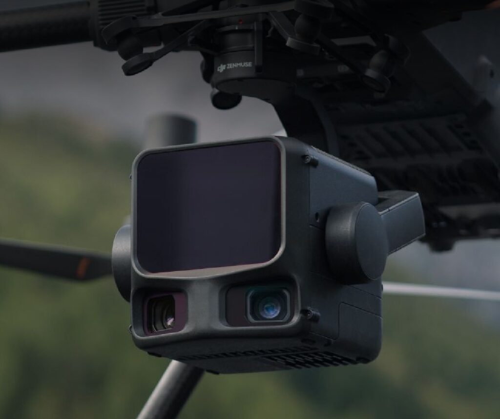
The DJI Zenmuse L3 represents a revolutionary leap in aerial surveying and mapping through its advanced LiDAR technology and exceptional imaging capabilities. Designed for professionals who demand precision and efficiency, the DJI Zenmuse L3 combines a long-range 1535nm LiDAR sensor with dual 100MP RGB mapping cameras to deliver comprehensive, high-resolution data. This fusion allows for detailed 3D point cloud generation and true-color orthophotography, streamlining geospatial workflows on a scale previously unattainable in such a compact form.
Equipped with a high-precision positioning and orientation system, the DJI Zenmuse L3 achieves remarkable accuracy levels, boasting vertical accuracy within 3 to 5 centimeters and horizontal accuracy between 4 to 7.5 centimeters, depending on flight altitude. Its innovative multi-return LiDAR technology captures up to 16 returns per pulse, enabling superior penetration through dense vegetation and complex structures. These features make the DJI Zenmuse L3 indispensable for applications in forestry, urban planning, infrastructure inspection, and environmental monitoring.
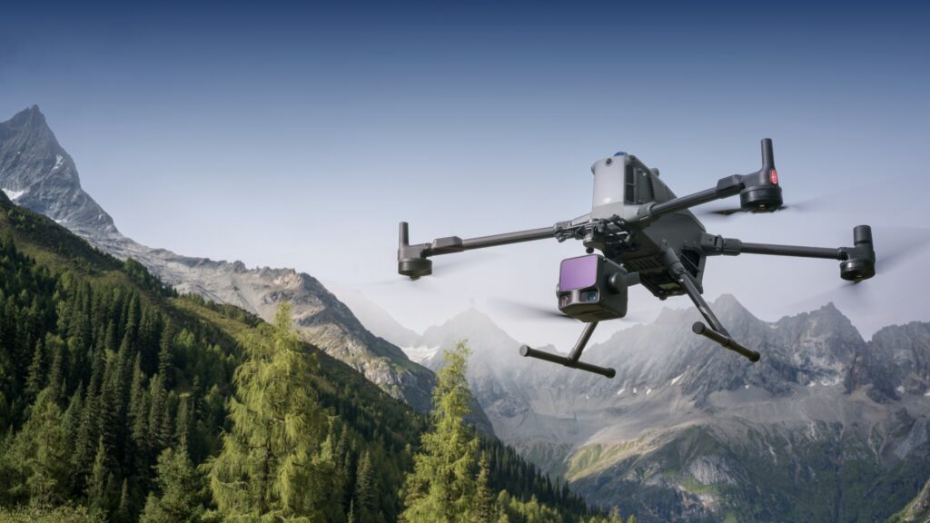
By integrating sophisticated hardware with smart software solutions, the DJI Zenmuse L3 empowers users to efficiently collect and process aerial data with unmatched clarity and reliability. Whether deployed on DJI Matrice series drones or integrated into custom platforms, this system elevates the standards of aerial remote sensing. For professionals seeking precision and operational excellence, the DJI Zenmuse L3 is the definitive tool for capturing true-to-life data across varied terrains and project scales.

Key Features
Explore the unparalleled capabilities of the DJI Zenmuse L3, the pinnacle of long-range LiDAR technology designed for professionals demanding precision, efficiency, and advanced aerial data acquisition. This all-in-one payload redefines the boundaries of aerial surveying by seamlessly integrating cutting-edge sensors and imaging systems within a compact, lightweight device. Whether you’re conducting forestry analysis, infrastructure inspections, or urban planning, the DJI Zenmuse L3 equips you with the ultimate tool to capture rich, accurate, and actionable data with ease.
Key Features of DJI Zenmuse L3:
1535nm Long-Range LiDAR Sensor: The DJI Zenmuse L3 is equipped with a next-generation 1535nm wavelength LiDAR sensor that delivers exceptional range and accuracy, capable of detecting objects up to 950 meters away, even under challenging lighting and reflectivity conditions. This enables operators to conduct high-altitude and long-range mapping missions while maintaining superior point density and surface detail. The advanced LiDAR system ensures consistent performance across various terrains — from dense forests to urban environments — offering professionals unmatched reliability in every mission.
Dual 100MP RGB Mapping Cameras: Featuring dual Micro Four Thirds (M4/3) 100MP RGB cameras, the Zenmuse L3 sets a new standard in aerial imaging. The dual-camera configuration captures ultra-high-resolution, true-color imagery with a 107° horizontal field of view, ensuring broad coverage with every flight. These cameras work in perfect harmony with the LiDAR sensor to generate true-color point clouds and detailed orthophotos, enhancing visualization, texture accuracy, and data precision. Whether used for photogrammetry, urban planning, or infrastructure inspection, this dual-camera system dramatically improves workflow efficiency and mapping clarity.
Survey-Grade Accuracy: Engineered for professional surveying applications, the DJI Zenmuse L3 achieves vertical accuracy up to 3 cm and horizontal accuracy as fine as 4 cm under optimal conditions. This survey-grade precision ensures dependable results for engineering surveys, construction monitoring, and environmental analysis, reducing the need for additional ground control points. Combined with DJI’s advanced GNSS and IMU systems, users can trust the L3 to deliver consistent, reliable, and repeatable measurements on every mission.
Multi-Return LiDAR Technology: With support for up to 16 returns per laser pulse, the Zenmuse L3 excels in penetrating vegetation, tree canopies, and complex structural layers to reveal ground surfaces with remarkable clarity. Its adjustable pulse repetition rate allows users to fine-tune performance based on mission requirements — whether capturing high-density point clouds in intricate urban settings or broader scans over natural terrain. This feature makes the L3 exceptionally versatile across applications such as forestry management, corridor mapping, and powerline inspections.
Seamless Integration and Workflow: The DJI Zenmuse L3 is designed for effortless integration with the DJI Matrice 350 RTK and Matrice 300 RTK platforms, working seamlessly with DJI D-RTK 3, DJI Pilot 2, and DJI Terra software. This unified ecosystem ensures smooth mission planning, real-time monitoring, and efficient post-processing — from flight to final deliverable. Operators benefit from simplified calibration, intelligent data synchronization, and streamlined LiDAR-to-map workflows that significantly reduce time and effort in the field.
Long-Range LiDAR Capabilities
The DJI Zenmuse L3 offers industry-leading long-range LiDAR capabilities designed to enhance large-scale surveying and mapping projects with superior accuracy and efficiency. Equipped with a 1535nm wavelength LiDAR sensor, the Zenmuse L3 achieves a maximum detection range of up to 950 meters on objects with as low as 10% reflectivity under 100 klx ambient light. This extended range supports operation at higher altitudes, significantly increasing single-flight area coverage and boosting overall mission efficiency.
One of the standout features of the DJI Zenmuse L3’s long-range LiDAR is its flexible pulse frequency, adjustable from 100 kHz to 2 MHz. This enables operators to optimize the balance between power consumption and data density based on specific mission requirements. The LiDAR system supports up to 16 returns per pulse, which offers exceptional penetration through dense vegetation and complex structures, bringing unparalleled detail and richness to point cloud data.
Dual 100MP RGB Mapping Cameras
The DJI Zenmuse L3 is equipped with dual 100MP RGB mapping cameras that significantly enhance accuracy and efficiency for aerial mapping professionals. These cameras feature Micro Four Thirds (4/3) CMOS sensors and a mechanical shutter designed to deliver high-fidelity imagery with outstanding clarity even in challenging lighting conditions. This capability allows the Zenmuse L3 to capture true-color orthophotos and create richly detailed, colorized point clouds synchronized precisely with the LiDAR data.
Moreover, the dual cameras offer a wide horizontal field of view of 107 degrees, considerably broader than the LiDAR scan angle. This expansive view enables efficient data capture covering larger areas per flight, optimizing mission time and operational costs. Even with a lower LiDAR side overlap of 20%, the system effectively collects data for both digital orthophoto maps and digital elevation models within a single flight, driving greater workflow efficiency without sacrificing data quality.
The ground sample distance (GSD) provided by the DJI Zenmuse L3’s dual 100MP cameras reaches 3 centimeters at a 300-meter flight altitude, supporting high-resolution, survey-grade photogrammetry. The cameras’ fast shooting intervals, down to 0.5 seconds for 25MP images, facilitate capturing precise aerial images at higher speeds, which is critical for large-scale geospatial projects requiring swift and accurate data collection. Additionally, the L3’s advanced image synchronization with LiDAR ensures seamless data alignment, minimizing post-processing time. Its integration with DJI Terra and DJI Pilot 2 further streamlines mission planning, data management, and 3D model reconstruction, empowering professionals to deliver reliable, actionable insights faster than ever before.
Specifications
| Specification | Details |
|---|---|
| LiDAR Wavelength | 1535 nm |
| Maximum Effective Range | 950 meters (on 10% reflectivity targets) |
| LiDAR Pulse Frequency | Adjustable, 100 kHz to 2 MHz |
| Number of Returns | Up to 16 returns per pulse |
| RGB Cameras | Dual 100MP Micro Four Thirds (M4/3) sensors |
| RGB Camera Field of View | Horizontal 107° |
| RGB Image Resolution | 100 MP per camera, true-color orthophotos |
| Vertical Accuracy | Approximately 3 cm (at 120 m altitude) |
| Horizontal Accuracy | Approximately 4 cm (at 120 m altitude) |
| Positioning System | High-Precision POS integrated |
| Stabilization | 3-axis gimbal stabilization |
| Compatible Platforms | DJI Matrice series drones |
Applications Across Industries
The DJI Zenmuse L3 is more than just a high-precision LiDAR and RGB payload — it’s a versatile aerial solution built to empower professionals across industries. By combining cutting-edge LiDAR scanning with dual 100MP RGB cameras, the L3 delivers unmatched accuracy, efficiency, and data depth. Integrated with DJI Terra and DJI Pilot 2, it offers a seamless end-to-end workflow from mission planning to 3D model generation. Whether it’s capturing fine topographic details or monitoring large infrastructure networks, the Zenmuse L3 provides reliable results that redefine aerial mapping standards.
Key Industry Applications of the DJI Zenmuse L3:
Topographic Surveying & Large-Scale Mapping:
Ideal for creating precise digital elevation models (DEM), contour maps, and orthophotos, the L3 accelerates mapping operations with exceptional accuracy. Its LiDAR system and dual cameras reduce overlap requirements, enabling efficient coverage of vast terrains in fewer flights — cutting both mission time and operational costs.Forestry & Vegetation Management:
Equipped with multi-return LiDAR and superior penetration capabilities, the L3 captures detailed canopy, mid-layer, and ground data. It supports biomass estimation, carbon stock analysis, and vegetation health assessment, providing valuable insights for sustainable forest management and ecological research.Infrastructure Inspection & Energy Sector:
The L3 is built for precision asset monitoring, offering detailed visualization of power lines, pipelines, bridges, railways, and communication towers. Its Power Line Follow Mode and advanced obstacle detection enhance inspection accuracy and operational safety. Combined RGB and LiDAR data enable 3D reconstruction and defect detection, facilitating preventive maintenance and improving asset lifespan.Urban Planning & Construction Monitoring:
Delivering high-resolution 3D models, orthophotos, and volumetric measurements, the L3 empowers architects, engineers, and planners with actionable data. From progress tracking to site analysis and infrastructure development, it ensures consistent, survey-grade results that streamline construction and urban design workflows.Emergency Response & Disaster Management:
In critical scenarios, the L3’s rapid data capture and real-time terrain modeling enable responders to evaluate damage, assess accessibility, and plan effective interventions. It assists in search and rescue operations, post-disaster reconstruction, and environmental risk analysis, making it an invaluable tool for government and humanitarian agencies.
Conclusion
When it comes to professional aerial surveying and mapping, the DJI Zenmuse L3 stands out with its remarkable long-range LiDAR capabilities. This payload features a 1535nm wavelength sensor capable of detecting objects up to 950 meters away, even under challenging low-reflectivity conditions. This extended range allows users to perform high-altitude flights with enhanced safety while capturing highly detailed spatial data, making the DJI Zenmuse L3 an ideal solution for large-scale mapping and topographical surveys.
The adjustable pulse rate of the DJI Zenmuse L3, ranging from 100 kHz to 2 MHz, offers flexibility for different mission requirements, balancing data density and power consumption. Its support for up to 16 returns per laser pulse ensures superior penetration through dense vegetation and complex structures, delivering comprehensive point cloud datasets. This capability significantly improves terrain modeling accuracy and data completeness, essential for applications like forestry management, infrastructure inspection, and environmental monitoring.
Overall, the DJI Zenmuse L3’s long-range LiDAR capabilities combine precision, efficiency, and extensive coverage in a compact payload. When integrated with DJI’s Matrice drone series and ecosystem software, it empowers professionals to conduct swift, precise, and comprehensive aerial data acquisition, optimizing workflows and delivering high-quality mapping and surveying results.