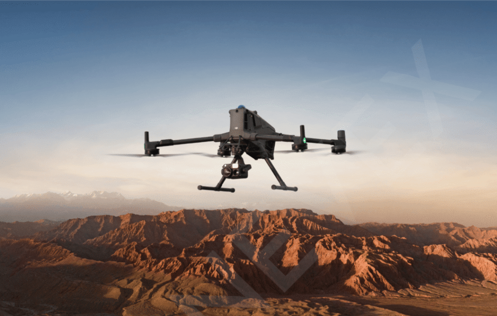
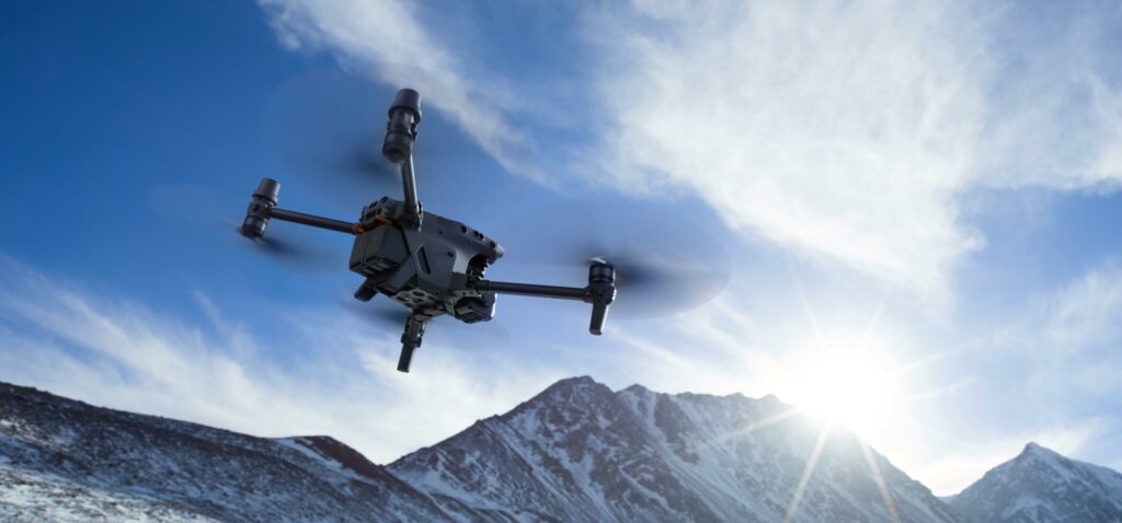
DJI Matrice M30T: The Compact Powerhouse for Enterprise Missions
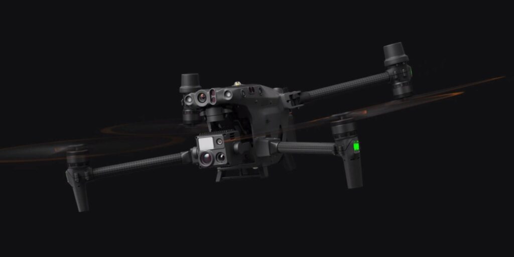
DJI Matrice M30T is designed as a compact but highly capable enterprise drone that brings high-end sensing and reliability into a portable airframe. DJI Matrice M30T combines a wide camera, a powerful zoom camera, an integrated thermal sensor, and a laser rangefinder, giving operators the ability to capture detailed visual, thermal, and distance data in a single flight. DJI Matrice M30T is built for field teams who need rapid deployment, rugged construction, and dependable performance in demanding environments.
With its multi-sensor payload, DJI Matrice M30T excels in inspection, public safety, and mapping workflows. The zoom camera lets crews read labels, cracks, and hotspots from a safe distance, while the thermal sensor highlights temperature anomalies in assets like power lines, solar farms, or industrial plants. The laser rangefinder adds precise coordinates and distance readings to every point of interest, which is invaluable for accurate reporting and follow-up maintenance. This makes DJI Matrice M30T a strong fit for organizations looking to standardize on one platform for both daylight and low-visibility missions.
Beyond imaging, DJI Matrice M30T benefits from robust flight performance and enterprise software integration. Weather-resistant construction, long flight times, and advanced obstacle-sensing systems support safer operations in complex sites, from cities to remote infrastructure. Integration with mission-planning and fleet-management platforms streamlines data handling, compliance, and collaboration between field teams and command centers. For enterprises that need a balance of portability, sensor depth, and operational resilience, DJI Matrice M30T stands out as a versatile, future-ready choice.
Specification
| Category | Key Specification |
|---|---|
| Aircraft dimensions | Unfolded (no props): 470 × 585 × 215 mm; Folded: 365 × 215 × 195 mm |
| Weight | Approx. 3.77 kg with two TB30 batteries; max takeoff weight about 4.07 kg |
| Diagonal wheelbase | 668 mm |
| Max flight time | Up to 41 minutes in ideal conditions; max hover time ~36 minutes |
| Max speed | 23 m/s (≈82 km/h) horizontal; ascent 6 m/s; descent 5–7 m/s depending on mode |
| Max service ceiling | 5,000 m AMSL with standard props; up to 7,000 m with high‑altitude props |
| Max wind resistance | 12 m/s (≈43 km/h) |
| Ingress protection | IP55 weather rating for dust and water resistance |
| Operating temperature | −20 °C to 50 °C (−4 °F to 122 °F) |
| Positioning systems | GNSS: GPS, Galileo, BeiDou; RTK support for centimeter‑level accuracy |
| Hover accuracy | With vision or RTK: ±0.1 m vertical, ±0.3 m horizontal; GNSS only up to ±1.5 m horizontal |
| Obstacle sensing | Omnidirectional vision plus infrared sensors; obstacle range typically 0.1–10 m depending on direction |
| Main battery | TB30 Intelligent Flight Battery, 5880 mAh, 26.1 V, 131.6 Wh, Li‑ion 6S |
| Battery operating range | −20 °C to 50 °C; hot‑swap supported via BS30 battery station |
| Wide camera | 1/2″ CMOS, 12 MP; 24 mm eq. focal length; f/2.8; DFOV 84°; 4K/30 fps video; 4000 × 3000 stills |
| Zoom camera | 1/2″ CMOS, 48 MP; 113–405 mm eq. focal length (21–75 mm physical); 5×–16× optical, up to 200× hybrid; 8K photos, 4K/30 fps video |
| Thermal camera | 640 × 512 resolution at 30 fps; 13 mm lens, DFOV ~61°; temperature measurement from −20 °C to 150 °C (high‑gain) and higher in low‑gain modes |
| Thermal palettes | Multiple color palettes such as White Hot, Black Hot, Iron Red, Rainbow, Medical, Arctic, etc. |
| Laser rangefinder | 905 nm wavelength; range approx. 3–1,200 m on a 20% reflective 0.5 × 12 m target; accuracy ±(0.2 m + D × 0.15%) |
| FPV camera | 1920 × 1080 resolution, 161° DFOV, 30 fps for pilot situational awareness |
| Transmission system | O3 Enterprise link, operating at 2.4 GHz and 5.8 GHz (region‑dependent) with multiple redundancy and automatic frequency hopping |
| Remote controller | DJI RC Plus with 7‑inch, high‑brightness display, internal + external WB37 battery support, IP54 rating, and up to ~6 hours run time with both batteries |
| Intelligent functions | Waypoints, Terrain Follow, Smart Pin & Track, Live Annotations, AI Spot‑Check, advanced RTH, and integration with DJI FlightHub 2 for fleet and mission management |
Flight Performance, Safety Systems and Portability
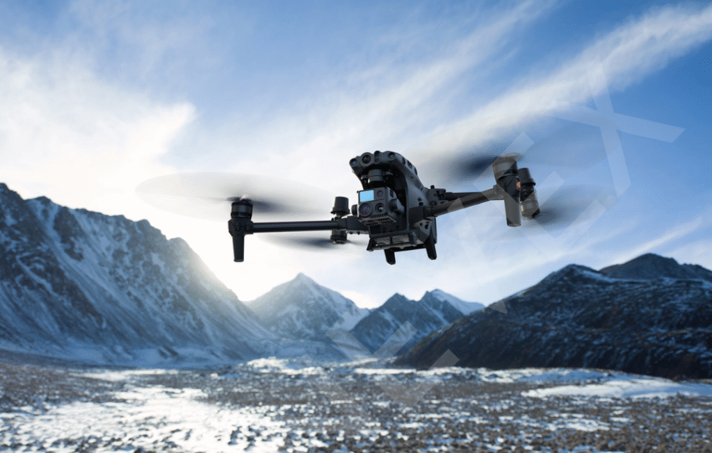
DJI Matrice M30T delivers a blend of top-tier flight performance, advanced safety systems, and field-ready portability for modern enterprise operations. Supporting up to 41 minutes of flight on a single set of batteries, DJI Matrice M30T enables large-area coverage for inspections or mapping missions with fewer interruptions. Its top speed of 23 m/s, service ceiling up to 7,000 meters, and outstanding wind resistance (12–15 m/s) let DJI Matrice M30T perform reliably in harsh weather, high altitudes, and demanding field environments.
Safety is a standout, with DJI Matrice M30T building in omnidirectional obstacle sensing—using visual and infrared sensors—to actively detect and avoid obstacles in six directions. Pilots benefit from automatic return-to-home, health management for key components, robust GPS and RTK support, and high-visibility anti-collision lights. The drone’s IP55 weather resistance, combined with an operational temperature range from –20°C to 50°C, ensures DJI Matrice M30T can fly in rain, dust, heat, and even subzero conditions without loss of performance, making it a true all-weather solution.
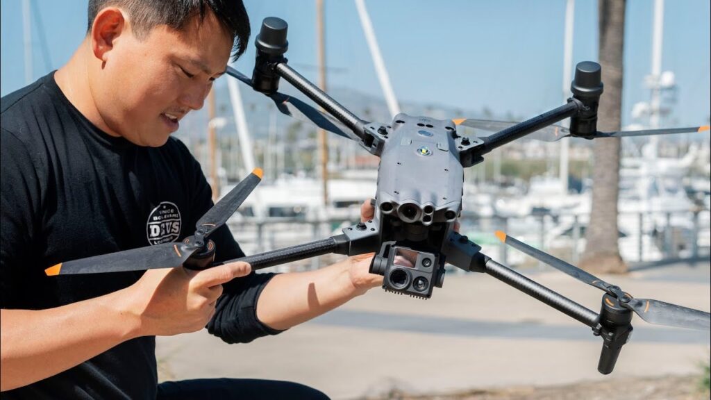
Portability is engineered into every aspect of DJI Matrice M30T. The quick-fold design, sub-4 kg takeoff weight, and hot-swappable batteries allow fast packing, deployment, and turnaround between missions—no special tools or bulky cases needed. Despite its compact size, DJI Matrice M30T brings professional-grade sensors and enterprise software compatibility, supporting advanced workflows without the transport headaches typical of bigger industrial UAVs.
Software Ecosystem: Mission Planning and Fleet Management
DJI Matrice M30T is more powerful when paired with its software ecosystem, which streamlines everything from pre-flight planning to post-mission reporting. Mission planners can design complex routes, set waypoints, and configure payload actions in advance, ensuring every DJI Matrice M30T flight captures the right data with minimal pilot workload. Cloud and fleet tools then centralize all this information for review, collaboration, and compliance across teams.
Integrated mission planning
Operators can create repeatable waypoint missions, terrain-follow flights, and AI Spot-Check routines tailored to inspection, mapping, or public-safety use cases. Once templates are built, DJI Matrice M30T can fly them consistently, improving data comparability across days, seasons, or sites and reducing pilot fatigue on long or complex operations.Real-time situational awareness
During live missions, maps, video feeds, and annotations sync to the operations center, allowing supervisors to see exactly what DJI Matrice M30T is seeing. Shared pins, polygons, and notes help coordinate ground teams, prioritize targets, and adapt plans instantly when new issues or opportunities are discovered in the field.Cloud storage and data management
Captured imagery, thermal data, and flight logs can be pushed to secure cloud workspaces where they are organized by project, asset, or date. This makes DJI Matrice M30T outputs easily accessible for engineers, managers, and clients, while preserving an auditable history of inspections, incidents, and maintenance evidence.Fleet and compliance oversight
Fleet dashboards track aircraft and battery health, firmware status, pilot usage, and mission histories. For organizations running multiple DJI Matrice M30T units, this central oversight supports better scheduling, proactive maintenance, and adherence to internal SOPs and aviation regulations, reducing downtime and compliance risk.Open ecosystem and integrations
Through SDKs and APIs, third-party developers can integrate DJI Matrice M30T with GIS platforms, CMMS systems, incident-management tools, or custom analytics pipelines. This lets enterprises plug the drone directly into existing digital workflows, turning each DJI Matrice M30T mission into a seamless part of their broader data and decision-making infrastructure.
Mapping, Surveying and Data Accuracy
DJI Matrice M30T can play a strong role in rapid mapping and engineering-grade situational awareness, especially when paired with its RTK positioning module and disciplined survey workflows. Although DJI does not market DJI Matrice M30T as a pure photogrammetry platform, many teams use it for construction progress maps, emergency scene documentation, and infrastructure corridors where high relative accuracy and fast deployment matter more than millimeter-perfect survey outputs.
For mapping and surveying, DJI Matrice M30T benefits from GNSS plus optional RTK to achieve centimeter-level positioning of the aircraft, which significantly tightens image geotags compared with GPS alone. When combined with well-distributed ground control points or check points, DJI Matrice M30T can generate orthomosaics and digital surface models with horizontal errors typically in the low-centimeter to decimeter range—sufficient for volumetrics, cut‑and‑fill tracking, or progress measurement on many civil and industrial sites. Careful flight planning—high overlap, consistent altitude, and slower speed—further improves reconstruction quality.
Operational Advantages: Portability, Weather Resistance and Battery Ecosystem
DJI Matrice M30T is engineered for real-world field work, where portability, weather resilience, and reliable power matter as much as sensors or software. In a single package, it gives teams a foldable airframe that travels easily, an IP‑rated shell that shrugs off dust and rain, and a smart battery ecosystem built for intensive daily use. Together, these advantages let crews focus on the mission instead of fighting logistics and downtime.
Portability starts with the compact, folding design of the DJI Matrice M30T, which fits into a single backpack-style case and can be deployed by one or two people in minutes. Arms unfold quickly, props lock into place, and pre-set mission profiles mean the drone can be airborne soon after arrival on site. For organisations that move between rooftops, substations, towers, or disaster zones in a single shift, this small footprint makes DJI Matrice M30T far easier to stage and reposition than older, bulkier enterprise platforms.
Weather resistance is another core operational advantage. DJI Matrice M30T carries an IP55 rating, meaning it can continue flying in rain, dust, and strong winds, with an operating temperature range roughly from –20 °C to 50 °C. This lets teams keep collecting data during monsoon showers, winter cold snaps, or desert heat, instead of cancelling flights whenever conditions are less than perfect. The matched battery ecosystem adds to this resilience: TB30 smart batteries are hot‑swappable, perform well across the same temperature band, and can be recharged from about 20% to 90% in roughly half an hour using the BS30 charging station.
Conclusion
Operationally, the DJI Matrice M30T gives enterprises a balanced package of portability, ruggedness, and dependable power that fits demanding field realities. Its foldable design and sub‑4 kg take‑off weight mean teams can carry the aircraft, controller, and batteries in a compact kit, deploy within minutes, and move quickly between rooftops, towers, and remote sites without heavy cases or large crews. For organizations juggling multiple locations in a single day, this portability directly translates into more missions completed and less downtime.
Weather resistance is another key advantage. The DJI Matrice M30T is built to an IP55 standard, allowing safe operation in rain, dust, and strong winds, with an operating temperature window wide enough for hot summers and freezing winters. That resilience lets teams continue flying when lighter airframes would be grounded, keeping critical inspections, public-safety flights, and emergency assessments on track even when conditions deteriorate. Knowing the platform is designed for harsh environments also boosts pilot confidence during long, complex missions.
The battery ecosystem further strengthens day‑to‑day operations. Intelligent TB30 batteries support hot‑swap changes, so the aircraft can be back in the air within moments instead of waiting on lengthy recharge cycles. Paired with the BS30 charging station, which rapidly cycles multiple packs, teams can rotate batteries through charge, standby, and active use to maintain near‑continuous coverage. For utilities, construction firms, and emergency agencies, this combination of portability, weather hardening, and robust power management makes the DJI Matrice M30T a practical workhorse rather than a fair‑weather tool.